HET LAND - THE COUNTRY
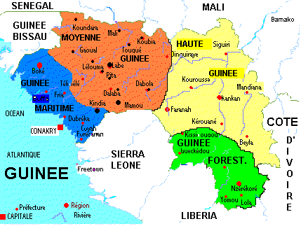
Guinée is officieel verdeeld in drie landschappelijke zones maar eigenlijk zijn het er vier want Guinée Forestiere
is een gebied op zich zelf.
Four natural regions form Guinea.
The Republic of guinea covers 245 860 sq km to the west of West Africa 10 north of the equator. It is bordered on the west by the Atlantic Ocean,
on the north by Guinea Bissau, Senegal and Mali, on the East by the Ivory Coast, and on the south by Sierra Leone and Liberia. A former French
colony, Guinea was the first francophone African country to gain its independence on 2nd October 1958, after having voted NO in the referendum
of 28th September 1958. Veritable water reserve of West Africa, Guinea gives birth to the large rivers of West Africa (Niger, Senegal, Gambia).
It has also Mount Nimba (1752m), the highest West African mountain. Guinea is divided into four natural regions with distinct human,
geographic and climatic characteristics.
Laag Guinée - Maritime Guinea
|
Basse-Guinée: Laag Guinée (Maritiem) is een gebied dat bestaat uit een lage en door vele kleine rivieren doorsneden
kustvlakte met een tropisch klimaat, een tropische vegetatie en een grootste hoogte van 1800 m (Kakoulima).
De kustvlakte bestaat voornamelijk uit moerassige mangrove gebieden. Basse-Guinée met haar prachtige stranden is een ideale
vakantiebestemming. Niet al te ver van de kust liggen enkele prachtig groene eilanden.
MARITIME GUINEA covers 18% of the country. The major ethnic groups are the Soussous, the Bagas, the Nalou, the Landoumas and the Miki Fore.
They are excellent rice growers and fishermen. Maritimes Guinea is a flat and narrow coastal plain bordered by estuaries. The major rivers
(Rio nunez, Rio Pongo, Konkoure) flow into the sea. The vegetation consists of coconut palms, palm groves and mangroves in the swamp areas.
Maritime guinea’s climate (South-guinean type) is marked by heavy rains, especially on the side where the monsoon blows.
Maritime Guinea with its vast sandy beaches that stretch for miles is an excellent destination for beach tourism. Not far offshore, there are
some beautiful green islands.
|
Midden Guinée - Mid Guinea
|
Moyenne-Guinée: midden Guinée bestaat uit het kale Fouta Djalonhoogland met een hoogte van 600 tot 1500 meter.
Moyenne Guinée wordt ook wel - net als het aldaar aanwezige massief - Fouta Djallon genoemd. Dit betekent
etymologisch ‘het land van de Peuls (Fouta) en Diallonkés (Djallon)’. Aan de westzijde van het massief,
ten oosten van Boké, ten noorden van Fria, Boffa en Dubréka, en ten zuiden van Télimélé bevindt zich een
overgangsgebied tussen Peuls en Soussous, terwijl ten oosten van het massief een overlap bestaat met de
Malinkés in Dinguiraye en Dabola. Andere etnische groepen in Moyenne Guinée zijn de Badiarankés, Coniaguis
en Bassaris in de préfecture Koundara, respectievelijk in de regio van Badiar, en in de sous-préfectures
van Youkounkoun en Guingan, de Tyapi in Gaoual, een minderheidsgroep Diakankés vooral in Touba, kleine
groepen Sarakolés als Linsan Saran en Manda Saran in Lélouma, en tenslotte de Limbas in de zuidelijke
zone van Mamou aan de grens met Sierra Leone.
MID GUINEA covers 1/5 of the country. Its population is essentially composed of shepherds. It also has the Djallonke and the Coniagui
who are farmers. Mid-guinea is dominated by the Fouta-Djallon mountain range whose highest peak, Mount Laura (1515m) is found in the north,
in the Mali mountains. The center has high plateau ranging between 600m and 1500m. the most important rivers in the region are the Tinkisso,
the Bafing and the Boyoke. The climate, of the Sudanese type, is characterized by low temperatures from November to March that can drop to 16.
Rain is abundant in winter. For the exceptional beauty of its scenery of mountains and valleys, and its mild climate the Fouta-Djallon is often
referred to as the Switzerland of Africa.
|
Hoog Guinée - Upper Guinea
|
Haute-Guinée: Hoog Guinée bestaat uit vlakten met savannevegetatie waar de hoogten van de Fouta Djalon overvloeit in
uitgestrekte vlakten met savanneklimaat en schaarse savannevegetatie. Haute Guinée wordt in meerderheid bevolkt
door de Malinkés. Zij leven samen met andere etnische groepen. De Diallonkés leven in de noordelijke streken
Dinguiraye en Siguiri aan de grens met Mali maar ook ten westen van de prefectuur Faranah en in enclaves in
Kouroussa. De Peuls Ouassoulounkés (een mengvorm van Peuls en Malinkés) komen voornamelijk voor in Mandiana.
De Kourankos zijn geconcentreerd in Kouroussa en Faranah. De Koniankés bewonen de préfecture Kérouané. Een
overgangsgebied tussen Malinkés en Peuls ligt in het westen van Haute Guinée.
UPPER GUINEA is a savannah region covering 41% of the country. Its population is in the majority of Malinke ethnic origin
whose traditional activities are farming, hunting and cattle raising. Upper Guinea is a savannah region suffering in several
places, desertification. It is faced with brush fires and deforestation due tot he cut and bum farming system. The Sudanese
climate, characteristic of Upper Guinea, is warm and dry with a predominant harmattan in March. The year is divided into
two seasons of equal length, the dry season from November to April and winter from May to October.
|
Regenwoud Guinée - (Rain)Forest Guinea
|
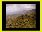
Guinée-Forestiere: Guinée Woud is een dicht bosgebied/regenwoud dat in het ZuidWesten van Guinee ligt aan
de grenzen met Liberia en Ivoorkust. Hier wonen voornamelijk Mandingo's en het is een handelscentrum tussen de
omringende landen. In dit gebied wonen veel fetish (medicijnmannen) die de traditionele kunst van het genezen kennen.
Zonder chemische toepassingen weten zij uit de natuur producten te winnen waarmee succesvol malaria, gele koorts,
tyfus en andere ziekten behandelen. Veel geheimen van Afrika liggen verscholen in dit prachtige natuurgebied.
FOREST GUINEA is both forested and mountainous. Dense forest is now threatened by intense exploitation of its resources.
Forest Guinea is inhabited by an ethnic mosaic: the Kissi live in the Kissidougou and Gneckedou Prefectures; the Kono,
the Manon (N’zerekore and Zomou Prefectures), the Thomas, the Thomas Minant (Macenta), the Konianke (Beyla Prefecture).
The foresters are cultivators and planters. The economy of Forested Guinea suffers from the distance between the region
and the capital, Conakry, where the port and the principal Guinean economic structures are situated.
|
|

